This year 2022 is marked by the celebration of the 500 years of Nebrija and the 150th anniversary of the birth of Pio Baroja (San Sebastian 1872 – Madrid 1956).
Baroja is a Spanish novelist, considered by critics to be Spain’s most important 20th century novelist. He was born in San Sebastián (Basque Country) and studied medicine in Madrid, the city he lived in for most of his life. His first novel was Vidas sombrías (1900), followed in the same year by La Casa de Aizgorri. This novel forms part of the first of Baroja’s trilogies, Tierra vasca, which also includes El Mayorazgo de Labraz (1903), one his most admired novels, and Zalacaín el Aventurero (1909).
With Silvestre Paradox (1901), he began the trilogy La Vida fantástica, an expression of his anarchistic individualism and pessimistic philosophy, of which the works Camino de Perfección (1902) and Paradox Rey (1906) also form part. But the work for which he became best known outside of Spain was the trilogy La Lucha por la Vida, a moving description of Madrid’s lowest classes, and made up of La Busca (1904), Mala Hierba (1904) and Aurora roja (1905).
He travelled around Spain, Italy, France, England, Holland and Switzerland, and in 1911 published Las Inquietudes de Shanti Andía and El Árbol de la Ciencia, possibly his most perfect novel. Between 1913 and 1935 there appeared 23 volumes of a historical novel, Memorias de un hombre de acción, based on the conspirator Eugenio de Avinareta, one of the author’s ancestors who lived in the Basque Country at the time of the Carlist Wars.
He was appointed member of the Real Academia Española in 1935 and spent the Spanish Civil War in France, returning in 1940. Upon his return he set up home in Madrid, where he lived a life removed from any public activity until his death in 1956. Betweeen 1944 and 1948 his Memorias was published in seven volumes, a work of the utmost interest for studying his life and oeuvre. In all, Baroja published over one hundred books.
Using elements from the picaresque novel tradition, Baroja chose as his main characters people marginalised from society. His novels are replete with incidents and clearly depicted characters and are outstanding for their natural dialogue and impressionistic descriptions. A master of realistic portrayal, particularly when the setting was the Basque Country of his birth, he has an incisive, vivid and yet impersonal style; some have attributed this apparent limitation of registers to a desire for precision and sobriety. He had considerable influence on the Spanish writers who came after him, such as Camilo José Cela and Juan Benet, as well as on many foreign writers, most notable among whom was Ernest Hemingway.
In English, archive.org has some interesting books by Pio Baroja:
The Royal Inland Road or Camino Real de Tierra Adentro is one of the many roads built in America by Spain between the 16th and 19th centuries.
At the moment of maximum expansion, the Spanish territories included almost three quarters of the current United States, all of current Mexico and the west coast of Canada.
The US states of California, Nevada, Colorado, Utah, New Mexico, Arizona, Texas, Oregon, Washington, Idaho, Montana, Wyoming, Kansas, Oklahoma, Louisiana, Florida, Alabama, Mississippi and Alaska were part of the Spanish Empire.
The same happened with the southwestern part of British Columbia of present-day Canada were in the hands of Spain within the Viceroyalty of New Spain. In Alaska, the occupation was limited to a few trading posts that would later be abandoned.
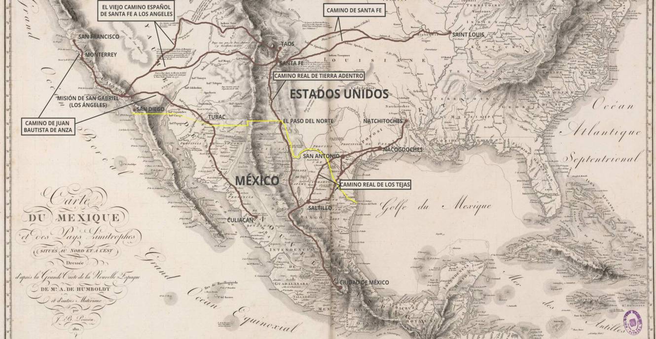
Historical-geographical map that shows in great detail the history, protagonists and limits of what became the Spanish possessions in the territories of present-day Canada, USA, Mexico and Central America -the American part of the Viceroyalty of New Spain Wikimedia Commons.
For decades, the Spanish legacy penetrated the territories that are now part of the United States through what were called Caminos Reales (Royal Roads). Originally these roads linked two capitals, but over time most of the routes that linked towns of certain importance came to use this meaning. Recently these trails have been recognized as heritage of American history and are now part of the US National Park Service. In fact, five of them are among its 19 National Historic Trails.
The Camino Real de Tierra Adentro was the most important of the Caminos Reales and linked Mexico City and Santa Fe in New Mexico. In fact it ended northern Santa Fe at nowadays Ohkay Owingeh (known by its Spanish name as San Juan de los Caballeros from 1589 to 2005, is a pueblo and census-designated place (CDP) in Rio Arriba County, New Mexico).
In its 2560 kilometers (1600 miles) of route it crossed the cities of Ciudad Juárez, El Paso and Albuquerque. It was popularly known as “Camino de Santa Fe” and also as “Camino de la Plata” since the entire route gave access to multiple mining areas and cities in New Spain producing silver and other minerals, such as Zacatecas, San Luis Potosi, Fresnillo or Chihuahua.
The Camino Real de Tierra Adentro was declared a UNESCO World Heritage Site in 2010.
Luis Laorden Jiménez, in his article Los caminos españoles en el oeste americano que son «National Historic Trails» de Estados Unidossays: “the road was long and dangerous. In 1638 it took six months to make the entire trip between Mexico City and Santa Fe without special incidents. By the beginning of the 19th century this time had been reduced somewhat, three months to go from Mexico City to Chihuahua and a month and a half from Chihuahua to Santa Fe”.
After Tenochtitlan was conquered by Hernán Cortés and his allies in 1521, Spanish conquistadors began a series of expeditions with the purpose of expanding their domains.
In April 1598, a group of military scouts led by Juan de Oñate, the newly appointed governor of the province of Santa Fe de Nuevo México, arrived at El Paso del Norte just south of present-day El Paso and Ciudad Juárez, where they celebrated the catholic feast of the Ascension on April 30, before crossing the river with the help of local Indians.
They then mapped and extended the route to what is now Española, where Oñate would establish the capital of the new province. This trail became the Camino Real de Tierra Adentro or Royal Inland Road (RIR), the northernmost of the four main “royal roads” – the Caminos Reales – that linked Mexico City to its major tributaries in Acapulco, Veracruz, Audiencia (Guatemala) and Santa Fe.
The second part of the RIR began at the Plaza de Armas of the town of San Felipe el Real de Chihuahua, today’s city in the Mexican state of Chihuahua, in front of the great baroque cathedral of San Francisco and the palace of the Spanish governor.
Leaving the city of Chihuahua behind, the road to the north crosses the Chihuahua desert, interrupted by the small but historic Sacramento river, and other streams that go to the lagoons of Encinillas, Patos, Santa Maria and Guzman. The inclement dune field of Samalayuca is there. Through Chihuahua passes the continental watershed and there are rivers that go to the Gulf of Mexico in the Atlantic and others to the Pacific, and there is also the peculiarity of the interior slopes made up of closed basins that end in closed lagoons in the desert.
After passing the Chihuahua desert, the Rio Grande river is reached and the famous crossing point where Juan de Oñate celebrated the first Thanksgiving Mass with the settlers who accompanied him in present-day U.S. territory on April 30, 1598, where Ciudad Juárez is now located, which was formerly called El Paso del Norte, in the State of Mexico, and on the other side of the river is the new city of El Paso at the end of the 19th century in the United States, which historically should have belonged to the State of New Mexico, but because of the railroad and for reasons of greater power, it belongs to the State of Texas. In El Paso del Norte was the Guadalupe Mission where the troubled Spanish survivors fled when they had to abandon Santa Fe and the towns of New Mexico because of the Pueblo Indian rebellion in 1680.
After the Pueblo Revolt, the Spanish Crown decided not to abandon the province altogether but instead maintained a channel to the province so as not to completely abandon their subjects remaining there. The Viceroyalty organized a system, the so-called conducta, to supply the missions, presidios, and northern ranchos. The conducta consisted of wagon caravans that in the beginning departed only every three or four years from Mexico City to Santa Fe. Later the expeditions were annual. Normally there were 32 wagons organized in 4 groups of 8, which when they could go in parallel rows, and in the first one the Spanish flag always flew. Everything was carried in the wagons and it was important that there were operators with spare parts to repair the frequent breakages of the axles and wheels. In each day it was usual to travel three to five leagues. The trip required a long and difficult journey of six months, including 2–3 weeks of rest along the way.
Many were the uncertainties that the conducta and other travelers faced. River floods could force weeks of waiting on the banks until the caravan could wade across. At other times, prolonged droughts in the area could make water scarce and difficult to find.
Beyond the sustenance needs, the greatest danger to the caravan was that of local assaults. Groups of bandits roamed throughout the territory and threatened the caravan from the current state of Mexico to the state of Querétaro, seeking articles of value. And from the southern part of Zacatecas onward to the north, the greatest threat was the native Chichimecas, who became more likely to attack as the caravan progressed further north. The main objective of the Chichimecas was horses, but they would also often take women and children. A series of presidios along the way allowed for relays of troops to provide additional protection to the caravans. At night in the most dangerous areas, the caravans would form a circle with their wagons with the people and animals inside.
The northern part of the Royal Inland Road (RIR) goes from the crossing of the Rio Grande, current border between Mexico and the United States (actual cities of El Paso on the U.S. side and Ciudad Juarez, former Paso del Norte on the Mexican side) to Santa Fe, capital of the State of New Mexico.
The engineering works for the irrigation ditch and to be able to cross the river were important. El Paso del Norte was an important city in Spanish times. At the end of the XVII century it had a population of about 1,000 people, in 1760 it was about 4,000 and in 1800 it reached almost 7,000. The distinguished scientific traveler Alexander Von Humboldt in his 1808 work Ensayo político sobre el Reino de la Nueva España (Political Essay on the Kingdom of New Spain) makes reference to the good aspect of El Paso del Norte:
“At El Paso del Norte the travelers stop to provide themselves with the necessary provisions before continuing their journey to Santa Fe. The surroundings of El Paso constitute a delightful country, resembling the most beautiful sites of Andalusia. The fields are sown with corn and wheat; the vineyards produce excellent generous wines, which are preferred even to those of Parral in Nueva Vizcaya; the orchards abound with all the fruit trees of Europe, such as fig, peach, apple, and pear trees: as the country is very dry, an acequia conducts to the Paso the waters of the river of the North. The inhabitants of the presidio have a lot of work to do to maintain the dam that leads to the irrigation ditch the waters of the rivers, when they are very low. During the great floods of the Rio del Norte, in the months of May and June, the force of the current destroys this dam almost every year, and the way of restoring and reinforcing it is very ingenious: the inhabitants form baskets with stakes woven with tree branches, fill them with earth and stones and lower them in the middle of the current, which in its eddy leaves them in the place where the ditch separates from the river…”
After fording the Rio Grande the RIR followed its eastern bank for about six leagues and then parted from the river, forming a short cut like the rope that tightens the arc of the riverbed until it met the river again about sixty miles to the north after crossing the desert which was called the Jornada del Muerto (The Working Day of the Dead), because of the terrible lack of water. It goes from Las Cruces to Socorro, New Mexico. This particularly dry 100-mile (160 km) stretch was the most famous and also the most dangerous in New Mexico, where many hikers perished from thirst or heat.
The RIR continues for fifty leagues along the eastern bank of the Rio Grande passing through the Indian villages that were visited by Francisco Vázquez de Coronado in 1540-42. The first town after the “Jornada del muerto” is today called Socorro, which was the name Juan de Oñate gave to the village where he found friendly Indians who gave him water and food and thanks to whom the expeditionaries survived. Before reaching Socorro is the headquarters of the El camino Real International Heritage center installed in an excellent museum dedicated to the RIR inaugurated on November 19, 2005.
Past Socorro all the names are Spanish: Escondida, Magdalena, San Acacia, Alamillo, Contreras, las Nutrias, Veguita, Adelino, Valencia, Isleta, Sandía Albuquerque…
In Albuquerque the road leaves the proximity of the Rio Grande and begins the ascent to Santa Fe at the foot of the southern foothills of the Rocky Mountains, which have the special name of the “Sangre de Cristo”. The names continue to be Spanish: Alameda, Corrales, Placitas, Algodones, Cerrillos, Peña Blanca, Agua Fria and finally Santa Fe. Before arriving to Santa Fe is the “Rancho de las Golondrinas” which is an old Spanish hacienda converted into a living museum where several days a year the life of the Spanish era is recreated under the auspices of the Historical Foundation of Colonial New Mexico.
In addition to geographical hazards, the greatest danger came from the hostile Indians, especially the Apaches. In 1705, the newly appointed governor of New Mexico, Francisco de Cuervo y Valdés, on his journey from Mexico City to Santa Fe to take office, had to stop at El Paso del Norte despite having a military escort because he found the road overrun by Apaches. To protect the road between Chihuahua and El Paso del Norte, three presidios were founded, the first at Nuestra Señora del Pilar and San José del Paso del Norte at the ford of Rio Grande in 1682, the second at El Carrizal in 1758 and the third at San Elizario in 1774. The Indian threat was to continue during the time when this territory passed to the United States.
The RIR was actively used as a commercial route for more than 300 years, from the middle of the 16th century to the 19th century. During this time, the road was continuously improved, and over time the risks became smaller as haciendas and population centers emerged.
It is interesting to note that progress on these roads did not come from the improvement of infrastructure, which was impossible to meet due to the remoteness and isolation of the distances, but from the use of the most appropriate means of transportation in each case. On the route between Mexico City and Chihuahua, where the most important merchandise to be transported was silver and mercury for working the ore, and heavy metallic elements, wagons pulled by oxen or mules were preferred. Between Chihuahua and Santa Fe, for lighter goods, mule carts were preferred, as they were better adapted to the shortcuts in the road and were faster because they passed where the wagons could not. All this hustle and bustle on the RIR was left for history when the U.S. Santa Fe Railroad reached El Paso in 1881 and continued with another railroad on the Mexican side.
In South America, the main routes also communicated both the two oceanic slopes with each other, as well as the Caribbean Sea with the territories of the South:
The Royal Road from Lima to Caracas, passing through Quito and Santa Fe de Bogotá, crossing the Ecuadorian Andes (3,000 km)
The Royal Road Santa Fe de Bogota to Honda, a town in the Tolima department of Colombia, through the Cordillera Central to the Magdalena River (Honda) to connect by river to Cartagena de Indias
The Royal Road of Muleteers between Caracas and the port of La Guaira, Venezuela
The Royal Road to Upper Peru
The Royal Road from Lima to Buenos Aires or Upper Peru via Cordoba (3,000 km)
The Royal Road to the West, between Buenos Aires and Santiago de Chile, passing through San Luis and Mendoza
The Royal Road to Asuncion, between Buenos Aires and Asuncion, passing through Corrientes
The Royal Road to Chile between Valdivia, Osorno and Chiloé


